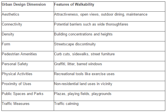
 Sustainable Cities shared a walkability post from photographer Christopher Berggren, that outlined the top 10 factors of walkability. Berggren runs a site called Planning Photography that provides photographic evidence (and the research notes) of the economic and social benefits of bike infrastructure and walkability. The photos, by the way, will inspire you to bike and walk and fight for the access to do so.
His post caught my eye because it featured one of my favorite walkable, bike-friendly cities — Copenhagen.
I work all the time to try to find nice snapshots of what would make for more walkable neighborhoods so I can whip them out at cocktail parties when people tell me Rochester is built around the car and there isn’t much we can do about it. “And what do you mean ‘more walkable?'” I like lists; they are easy.
Berggren’s reference for the 10 factors is The Brookings Institution. Brookings’ Walk this Way: The Economic Promise of Walkable Places in Metropolitan Washington DC report was released in 2012 in the wake of the recession and real estate crash. In the DC metro area, the suburbs the furthest from the city “experienced the starkest price decreases while more close-in neighborhoods either held steady or in some cases saw price increases.”
And that was an important distinction. The authors of the Brookings study believed this signaled a shift in real estate preferences for neighborhoods that were more walkable — mixed used, denser, full of amenities and access to transit.
The study outlined the economic benefits of walkability and of connecting walkable neighborhoods to other walkable areas. And it also outlined the top 10 criteria of walkability, which Berggren provided in the following table. I now share it with you so you can whip it out at cocktail parties: [Click here to see his original post.] 
Written by: Renee
Tags: walkable neighborhoods, mass transit, bike lanes, urban planning, walkability, bike boulevards,


No Comment